Remote Sensing Image Interpretation: Deep Be-lief Networks for Multi-Object Analysis
Duration
[2023 – 2024], Designation = Research Associate
Supported by
This research was supported by the MSIT (Ministry of Science and ICT), Korea, under the ITRC (Information Technology Research Center) support program (IITP-2023-2018-0-01426) supervised by the IITP (Institute for Information & Communications Technology Planning & Evaluation).
The authors acknowledge Princess Nourah bint Abdulrahman University Researchers supporting Project number (PNURSP2023R54), Princess Nourah bint Abdulrahman University, Riyadh, Saudi Arabia.
Project Description
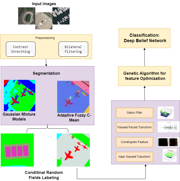
Object Classification in Remote Sensing Imagery holds paramount importance for extracting meaningful insights from complex aerial scenes. Conventional methods encounter challenges in achieving precision amidst diverse landscape features. This paper introduces an innovative hybrid model to enhance the accu-racy of remote sensing multi-object classification. Incorporating a feature-level fusion approach inspired by successful methods, we leverage Adoptive Fuzzy C-means segmentation for precise object classifica-tion and Conditional Random Field (CRF) labeling. Our model excels in capturing diverse features within remote sensing images using multiple feature extraction methods. The distinctive feature of our methodol-ogy lies in the thoughtful incorporation of a Deep Belief Network (DBN). Through rigorous experimental evaluations on two standard datasets, our proposed system demonstrates exceptional performance, em-phasizing its significant potential for advancing methodologies in remote sensing multi-object classifica-tion. This tactful integration results in substantial improvements, yielding high accuracies of 97.24% (UCM) and 96.84% (RESISC45). The proposed model is methodologically novel and effective solution for advancing remote sensing image classification.