Integrating Semantic Segmentation and Object detection forMulti-object labeling in Aerial Images
Duration
2023
Supported by
NONE
Project Description
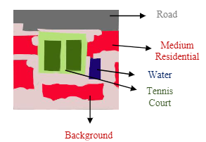
Aerial imagery is gaining significance across variousdomains, comprising agriculture, disaster management, andsurveillance. Durin this study, a unique method to tackle thepersistent problems in accurate and efficient multi-objectrecognition in aerial imagery has been introduced. Our suggestedapproach combines the abstraction of spectral and spatial texturedetails with the incorporation of a color space segmentationalgorithm. We convert the original data into a single feature spaceby utilizing multiple kernel learning (MKL), which improves featurerepresentation accuracy and, in turn, improves classificationaccuracy. Finally, various objects in aerial images may berecognized and categorized according to the application of markovrandom field. By addressing variances in illumination, orientation,and size, this novel approach seeks to provide a complete solutionfor improving multi-object recognition in aerial data.Our findingsdemonstrate a significant improvement in object detection accuracy98.13%.